Marojejy National Park is an ecological gem in Madagascar’s Sava region. Its unique biodiversity and conservation make it a crucial destination not only for tourists, but also for scientific research and nature conservation. Here are a few key points concerning its ecological importance:
Exceptional biodiversity: The park is home to a wide variety of animal and plant species, many of which are endemic, i.e. found nowhere else in the world. These include rare lemurs, birds, reptiles, amphibians and unique flora.
Forest conservation: The park’s mountain rainforests play a crucial role in regulating the climate and protecting against erosion. They are also an essential source of fresh water for local populations.
Scientific research: Thanks to its rich biodiversity, the park is a living laboratory for scientists and researchers from all over the world. It offers study opportunities to better understand ecosystems, species biology and the impacts of climate change.
Sustainable tourism: The park attracts ecotourists who come to admire its natural beauty and observe rare species. Sustainable tourism generates income for conservation and community development, while raising awareness of the importance of preserving these unique ecosystems.
Education and s
The Marojejy massif was discovered by French botanist Henri Jean Humbert of the Muséum national d'histoire naturelle in Paris in 1948. Humbert had previously visited numerous mountains in continental Africa and Madagascar, before coming to Marojejy. It was while climbing the Tsaratanana massif in 1937 that Humbert spotted the silhouette of the Marojejy massif in the Andapa district from the summit of Amboabory at 2,800 m altitude. He decided to organize a special mission to study these mountains. Between November 1948 and November 1950, he spent five months collecting a herbarium of 4,039 samples for study. After his intense fieldwork and analysis of the specimens, he published the book Une Merveille de la Nature in 1955, in which he describes the massif as “the most impressive in all of Madagascar, both in terms of its size and diversity of flora, and its totally untouched state”.
As soon as he returned from the field, Humbert redoubled his efforts to defend Marojejy and get it classified. On August 28, 1951, Pierre Boiteau was appointed rapporteur for a request for an opinion from François Mitterrand, Minister for Overseas France5. The massif became Madagascar's 12th and last integral nature reserve in 1952. The decree creating the reserve was issued on January 01, 1966. Under this status, the reserve was off-limits to all but duly authorized scientific expeditions. In so doing, it undoubtedly enabled the massif to survive the demographic growth and multiple anthropic pressures of the area.
In 1952, management was taken over by the Malagasy government through the Administration des Eaux, des Forêts et de la Conservation de Sol.
In 1993, the WWF was delegated by the Ministry of the Environment to manage the park under its supervision.
With a view to granting maximum benefits to the surrounding communities, the Ministry of the Environment, Water and Forests, together with WWF, carried out a study to change the park's status to that of a National Park.
Thus, in 1998, Marojejy became National Park n°13 (decree n° 98- 375 of May 19, 1998), finally allowing the public to visit. This status will enable the local population to benefit from economic spin-offs through job creation in the ecotourism sector.
In 2007, Marojejy National Park was designated a UNESCO World Heritage Site in the Atsinanana rainforest block, including Marojejy, Masoala, Zahamena, Ranomafana, Andringitra and Andohahela.
In 2009, during the political crisis on the Big Island, the illegal exploitation of precious woods in this World Heritage site was difficult to manage. In 2010, rosewood logging led to the Atsinanana rainforest being placed on the list of World Heritage in Danger.
In terms of management, WWF's involvement ended in December 2004.
In January 2005, the Association Nationale pour la Gestion des Aires Protégées took over management of the park.
On November 14, 2008, in order to promote management, the park was rebranded and its name changed to Madagascar National Parks, which continues to manage the park today.
Propithecus candidus
Lepilemur mustelinus
Eulemur albifrons
Eulemur rubriventer
Cryptoprocta ferox
Euryceros prevostii
Treron australis
Alectronenas madagascariensis
Dalbergia louvelii
Dalbergia baroni
Hapalemur occidentalis
Galidia elegans
Coua cuerela
Furcifer pardalis
Brookesia karchei
Uroplatus ebenaui
Sanzinia Madagacrariensis
Boa madagascariensis
Mantella laevigata
Most pressures are human activities that have negative impacts on conservation targets and biodiversity. A pressure could be active (i.e. ongoing human activity to date) or historical where it could be ceased but leaves persistent or anticipated negative impacts. The Marojejy/Anjanaharibe-Sud Management Unit manages three major types of pressure in Marojejy National Park: logging, clearing followed by fires and hunting.
Over the past three years, attempts at illegal mining have been noted during patrols in Marojejy National Park.
Since 2020, boundary violation by the riparian population has been noted by the manager. This boundary violation could be due to climate change, which is encouraging farmers to find and use fertile land for agricultural activities, in particular undergrowth vanilla cultivation. The park boundary was decreed by decree n°98-375 of May 19, 1998, but the change in vanilla prices a few years ago has also prompted boundary violations for cash crops.
It is also possible that politicians are taking advantage of the boundary conflict to disrupt Madagascar National Parks' mission.
A number of initiatives have been planned to address the environmental challenges and human pressures on the park.
Through carbon financing for sale 2020, Madagascar National Parks Marojejy has defined the following community activities for the year 2025
With a view to preserving Marojejy National Park from human exploitation, UNESCO, via the Conservation of Biodiversity and Sustainable Management of Natural Resources (Biocom) project, and the Ministry of Technical Education and Vocational Training are opening a Vocational Training Center (CFP) in 2024 in Sambava, dedicated to young people from the park's local community. The CFP will provide vocational training for 140 young people in metalwork and masonry. This year, 27 masonry apprentices from the park's neighboring communities benefited from professional training.
LCF (Lemur Conservation Foudation)
DLC (Duke Lemur Center SAVA)
Tafo mihavo
Depending on your means of transport :
-Parking : Andranobevava, Nosibe Angarangarana
-Frequency: Saturday, Tuesday, Thursday
-Fare/person: 140,000 Ar, please allow for luggage costs if over 20 Kg
- Duration: 3 to 4 days
- Continuous travel 24/24h
None
Madagascar Airlines scheduled flight to SAMBAVA (ATR)
- Landing at SAMBAVA airport
- Transfer by private car from Sambava to Manantenina welcome office
- Distance: 65 Km
- Duration: 1h to 1h30min
Then transfer by bush cab, Sambava to Manantenina welcome office
- Distance: 65 Km
- Duration: 1h30min to 2h30min
- Cost 7,000 Ar per person
Bonne période de visite (haute) saison: saison sec Aout, septembre, octobre et mi novembre
Autres saison : visite possible, saison de pluie est la bonne période de ‘observer les amphibiens
The reception office and interpretation center are located on the RN3b road, in the village of Manantenina, Maroambihy rural district, Sambava district,
65 km from Sambava, 40 km from Andapa
Rest shelter at park entrance 5.6km from reception office,
The camp has 6 well-equipped bungalows for up to 24 people, 3 tent pitches, 2 pit toilets, 2 dining shelters with cooking utensils, 01 gazebo.
The camp includes 2 fully-equipped bungalows for 8 people, 3 tent pitches, 1 pit toilet, 01 dining shelter with cooking utensils.
Download the reference document to find out more about park fees and charges.
Tours | Summary | Difficulty | Duration | Tour plans |
---|---|---|---|---|
Piste d’accès | At the beginning of the tour, before arriving at the entrance, visitors have the chance to discover the daily life of the local population: agriculture, their customs, species of chameleon, snake, etc. |
80 to 180m altitude |
2h walk |
|
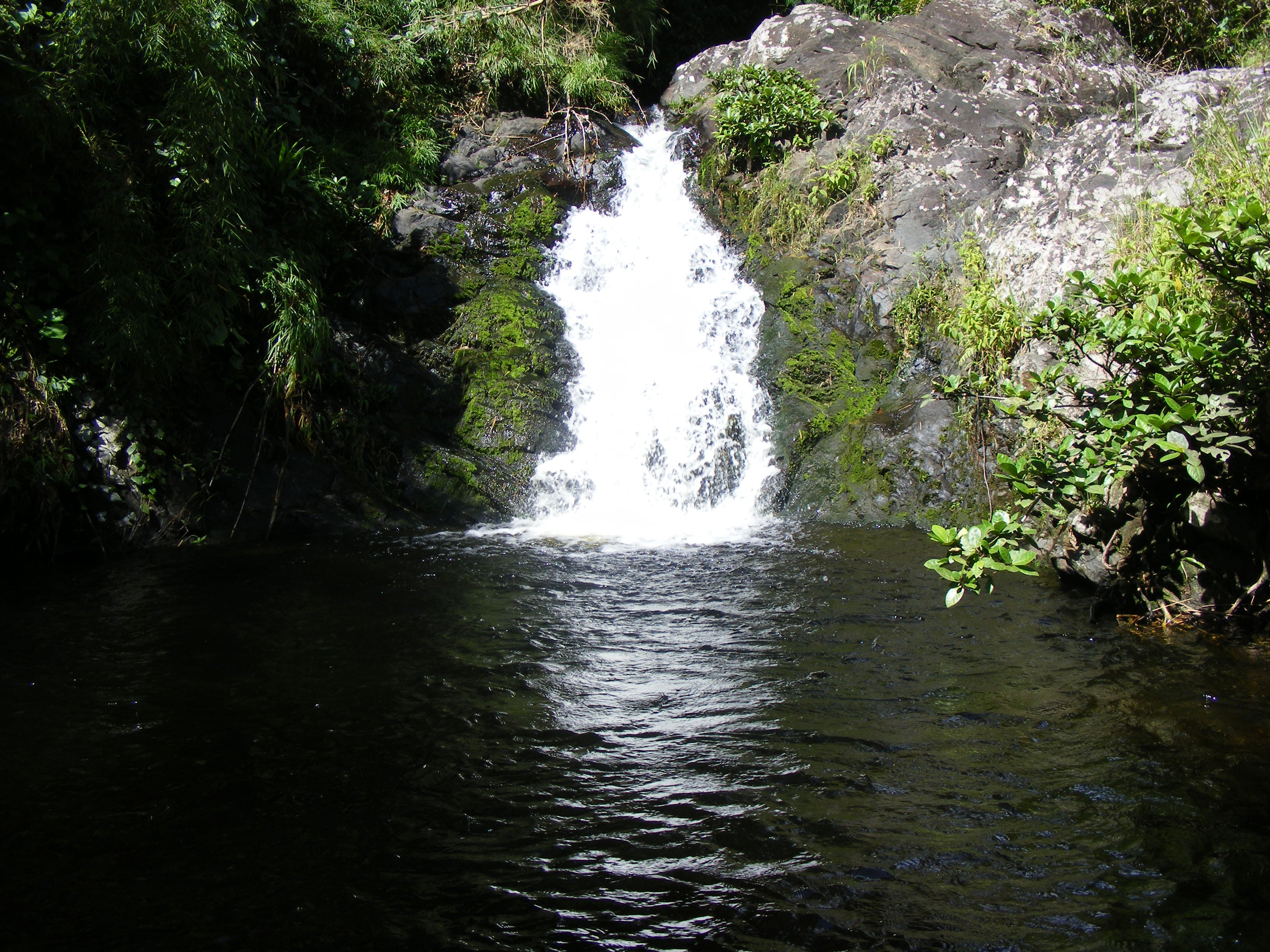
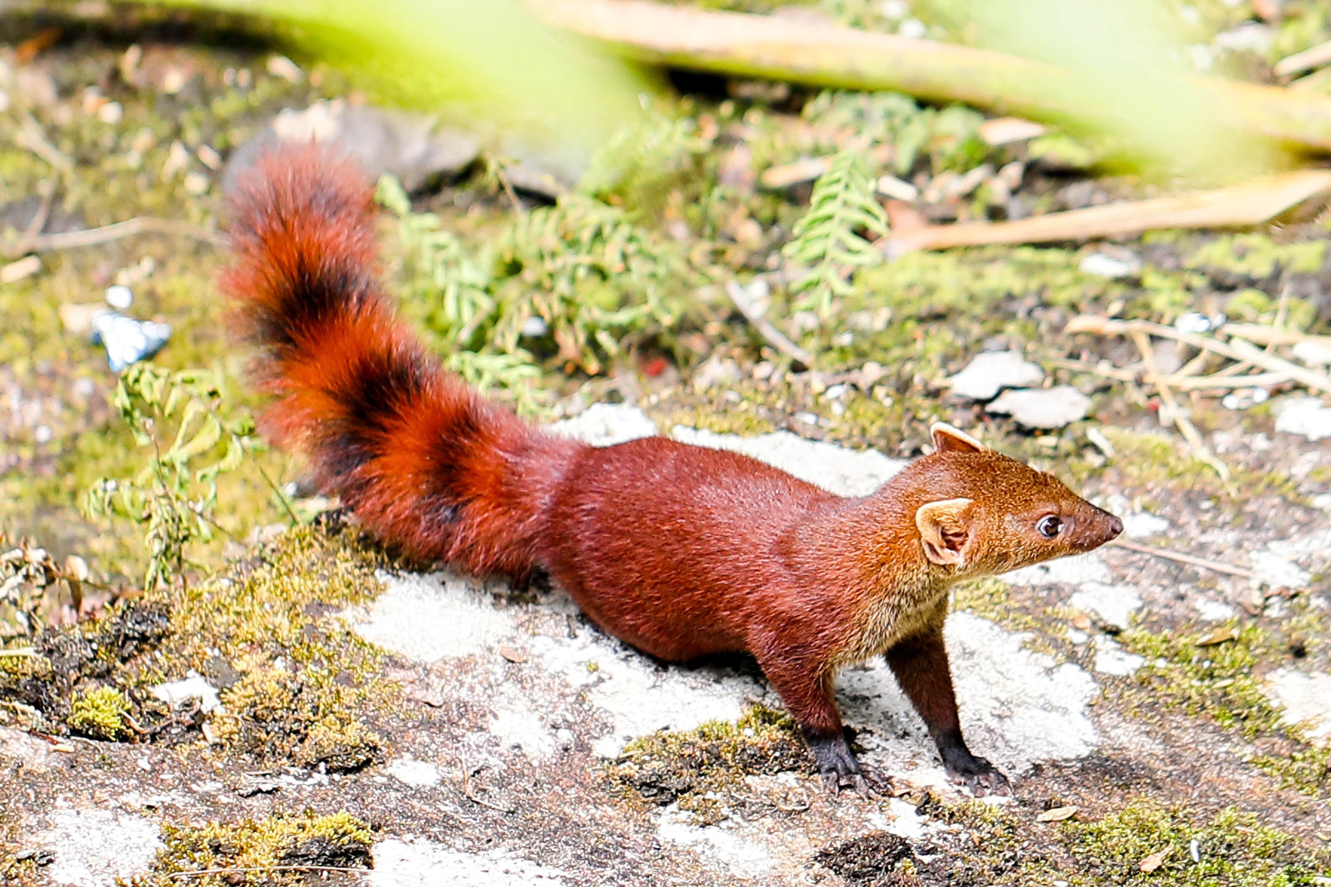
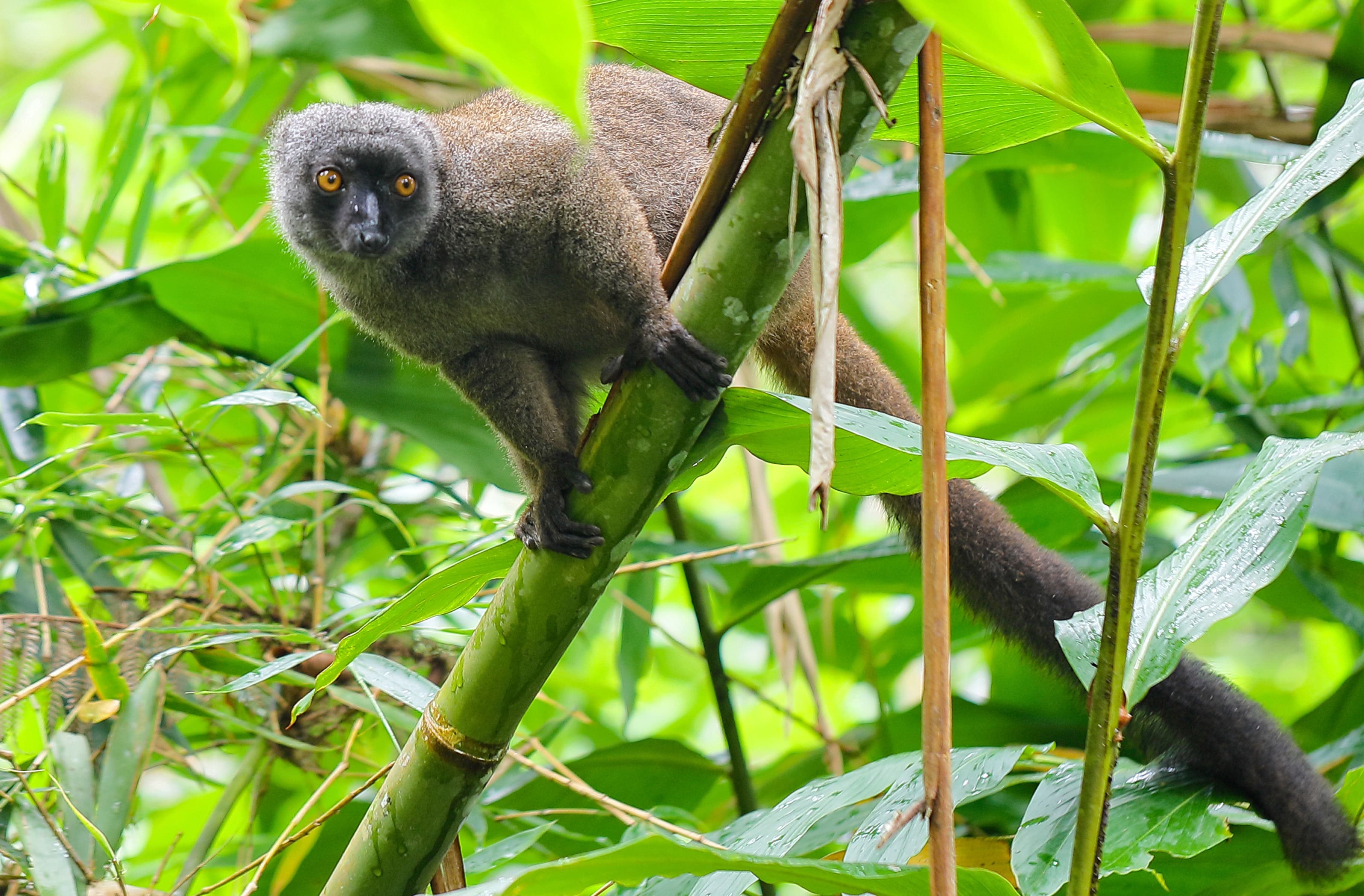
Mantella | Discover the low-altitude primary rainforest; you'll have the chance to meet reptile and amphibian species (such as Mantella laevigata, boophis, Sanzinia madagsacariensis etc.), lemur species (such as bamboo lemur, elmur albifrons), bird species (including Blue Coua, Prevost's Eurycere, etc.). Along the way, you'll take a short break in a natural pool on a natural waterfall; 30 min from Camp Mantella, you'll also have the advantage of visiting a beautiful Humbert waterfall estimated to be 40 m high. At Camp Mantella, at an altitude of 450m, there are six bungalows equipped with beds, sheets, matélas and oreillets, and a dining shelter with cooking utensils. Two shared pit toilets are available for visitors. 6 camping sites with tents are also available. |
Forest trail in natural rubble at 450 m elevation. Fairly steep slope. Hiking trail |
2 to 3 hours walk |
|
Piscine noire | Just 600m from the entrance, a circuit reserved for day-trippers is open for picnics, with the chance of encountering bird species such as blue coua, siketribe and white-fronted lemurs. This circuit, located in the low-altitude forest, offers the chance to admire a waterfall with a black pool. |
An easy circuit accessible to everyone 180m above sea level. |
30min |
|
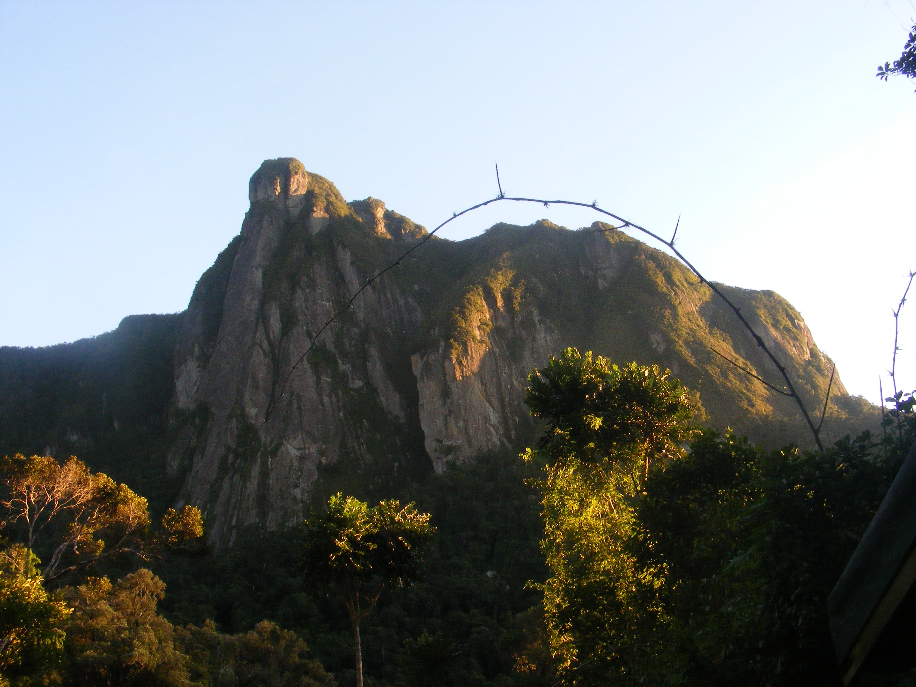
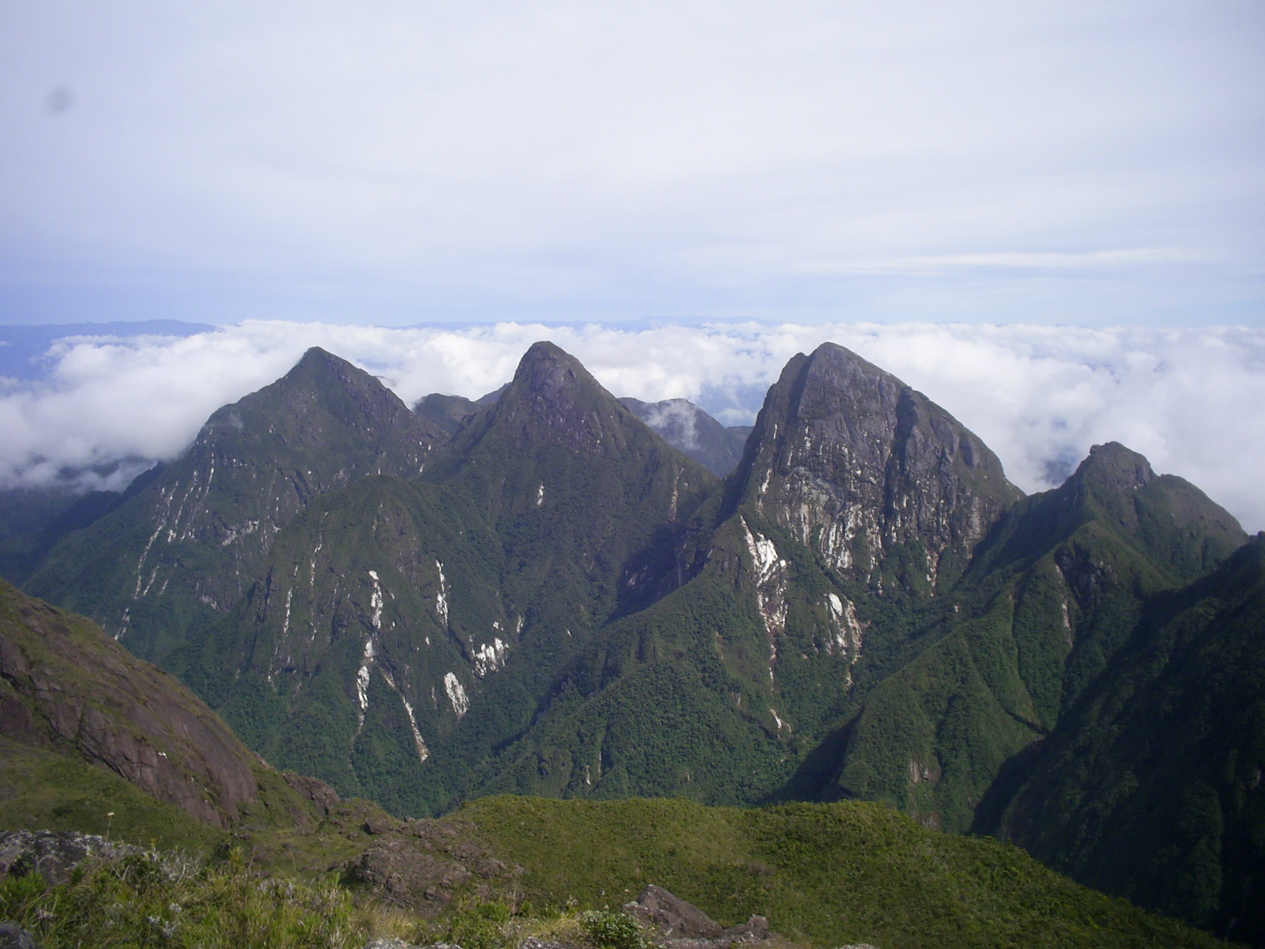
Simpona | Linking Camp Mantella and Camp Marojejya; along this circuit you'll find Brookesia Karchei, a species of endemic palm (Marojejya insignis); on this circuit you'll also have the chance to find Silky Sifaka, a species of lemur covered with extremely white fur endemic to the region; at Camp Marojejya is the boundary between lowland and mid-altitude forest. Beautiful views of granite cliffs and mountains covered in intense green forests are adored by visitors to Camp Marojejya. |
Passage on a circuit maintained on natural rubble, from 450m to 775m altitude |
1 to 2 hours' walk from Mantella camp |
|
Takthajania | In the Middle Forest, an old fossil, the famous takthajania perrieri, a plant from the time of the Dynausores discovered 120 million years ago, can be discovered 1km from Camp MarojejyaD. |
Difficult circuit 775 to 1000m altitude |
1h walk |
Immerse yourself in the unique biodiversity of our national parks and discover our commitment to conservation and ecosystem protection. Marvel at unspoilt landscapes and exceptional wildlife. Together, we create a model of responsible and beneficial coexistence