This protected area is located between the geographical coordinates 18°08′ and 18°15′ south latitude, and 48°48′ and 48°57′ east longitude, and covers a total area of 11,950 ha. The Reserve’s administrative office is based in Toamasina.
In physical terms, the Reserve is located at an altitude of between 300 and 1,600 meters. Its climate is tropical per-humid, with no marked dry season. Average annual rainfall is around 2,000 mm, spread over more than 180 days, while temperatures vary between 21°C and 24°C. The Reserve is crossed by several rivers, such as Sahanavo, Morongolo and Sahafatrana, which feed the Ivondro-Ivolobe river, and the Sahanalaotra river, which plays an essential role in irrigation and local activities.
The Mangerivola Special Reserve is representative of low- and medium-altitude forest types, and maintains the genetic stocks of several plant and animal species endemic to the Eastern ecoregion along the Mantadia-Zahamena corridor. It has a high faunal diversity, despite the anthropic pressure that has weighed on it since the date of the Reserve’s creation decree until 2001, when direct management by ANGAP, which became the current Madagascar National Parks, was effective.
Main ecological features :
From an ecological point of view, the Mangerivola Protected Area has potential economic value.
History
The Mangerivola Special Reserve was created in 1958 by decree N°58-10 of October 28, 1958. It is located in the Province of Toamasina, Atsinanana Region, straddling the districts of Toamasina II and Brickaville. It covers the rural communes of Anjahamana and Saviavy-Fito.
Endemic species
Birds: Of the 100 species recorded here, 63 are endemic to Madagascar, 23 are regional endemics and 33 of the 86 species are typical of eastern Madagascar.
Reptiles: Chamaeleontidae family: Brookesia superciliaris, Calumma furcifer, Calumma gallus Colubridae family: Geodipsias laphistia
Anphibians: Family Mantellidae: Mantella madagascariensis, Mantidactylus blommersae, M. cornutus, M. flavobrunneus, M. malagasius, M. perracae, M. phantasticus, M. redimitus, M. rivicola. Rhacophoridae family: Boophis boehmei, B. marojezensis, B. reticulatus, B. rufioculis, Platypelis pollicaris, Cophyla sp.
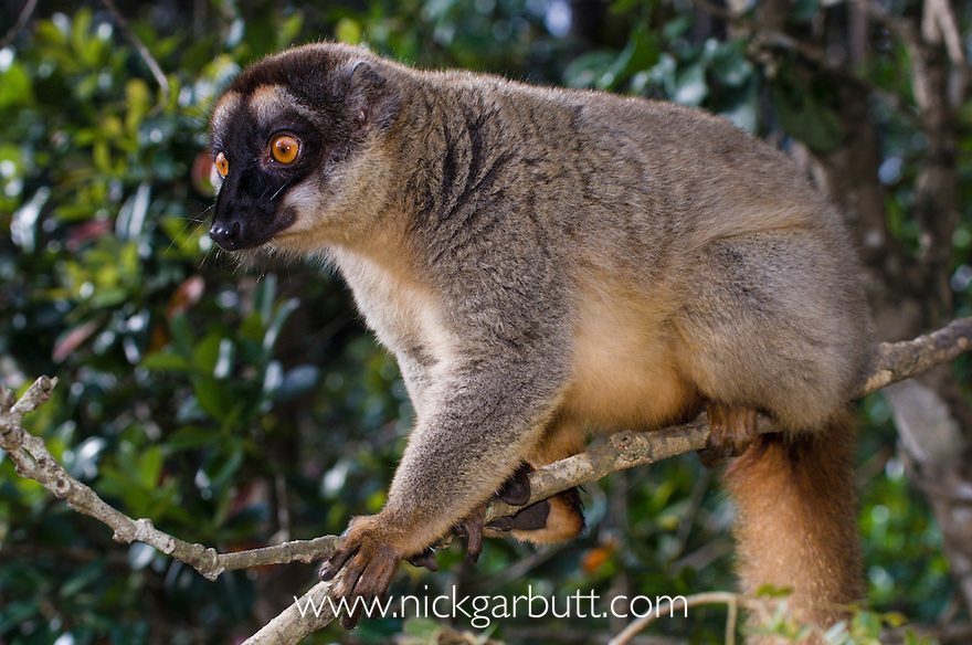
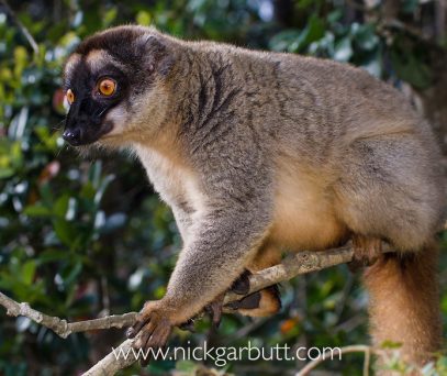
Fauna
The biological diversity of the reserve is even less well known, but it contains some rare endemic species. Take, for example, Tyto soumagnei (Red Owl), considered one of Madagascar's rarest endemics and the most endangered owl in the world, but currently in need of in-depth research into the precise locality and numbers of remaining individuals.
Flora
Of the 325 species recorded, 170 are endemic, representing 52%. These species are divided into 59 families. There are 5 families endemic to Madagascar: Asteropeiaceae, Melanophyllaceae, Physenaceae, Sarcolaenaceae and Sphaerosepalaceae.
Some species present in the Mangerivola Special Reserve have a naturally rare distribution or are highly exposed to human activities, making them threatened with extinction. Other species, although rare, are particularly vulnerable to logging and the various uses made of them. According to the GRAP Plan (Plan de Gestion National du Réseau d'Aires Protégées), the Mangerivola Special Reserve is classified in category IV by the IUCN (International Union for Conservation of Nature). This means that this Protected Area is dedicated primarily to conservation, with active management to ensure its preservation. The plan also emphasizes that the reserve possesses exceptional biodiversity but is exposed to high threats, justifying its classification in Strategy B.
The Development and Management Plan (PAG) for the Mangerivola Special Reserve is currently being validated for the period 2025-2029. Data from this plan indicate active management aimed at limiting deforestation and preserving critical habitats. Madagascar National Parks (MNP) structures its intervention around four major strategic axes.
Biodiversity conservation
A number of initiatives have been planned to address the environmental challenges and human pressures on the park.
Financial sustainability and partnership
Major pressures: Pressures linked to the illegal exploitation of natural resources (poaching, mining, logging) remain major threats to the Reserve. These activities, although declining in some categories, continue to represent a threat to habitats and wildlife.
Other pressures: Depending on the local context, the Mangerivola Special Reserve could be threatened by the spread of “Tavy” cultivation fires around the reserve.
Conservation, Support and Development
The updated Development and Management Plan (PAG 2025-2029) for the Mangerivola Special Reserve is still being validated. This document defines the strategic axes and action plan to be followed to ensure the sustainable development of the reserve.
As part of the management and good governance of the Protected Area (PA), Madagascar National Parks (MNP) has set up a co-management framework with local communities, called COSAP (Comité d'Orientation et de Suivi de l'Aire Protégée). As a support committee, COSAP plays an essential role in conservation. It monitors the monitoring activities carried out by the CLP (Local Protection Committee) sub-committee, and participates in decisions concerning the selection of micro-projects to support the development of the reserve's peripheral zone.
Community Development Projects
- Construction of a guardhouse underway to solve the problem of accommodation and to justify the effective presence of teams in the field;
- Twenty-nine kilometers of external boundary to be maintained;
- Target of 140 AGP patrol missions with 320 land surveillance objectives and 96 CLP patrol missions with 104 land surveillance objectives to be achieved;
- 20Ha of degraded habitats to be restored under passive restoration;
- 10Ha of degraded habitat to be reforested in the peripheral zone of the reserve.
From 2025, the Mangerivola Management Unit plans to implement four ecological development sub-projects:
- Maintenance of CSBI Ambinanivavony.
- Provision of materials for the maintenance of EPP Andranomadio.
- Rehabilitation of EPP Anivorano.
- Maintenance of CSB II Anjahamana (including roof renewal, painting and electrification).
In parallel, three social protection micro-projects are planned:
- Distribution of clove seedlings to members of the VOI and CLP of Mangerivola.
- Provision of bean seeds for pilot farmers (MVOI/MCLP) living around the reserve.
- Development of poultry farming (“gasy” chicken) for local populations.
Fund Madagascar National Parks' five-year strategic plan to ensure the sustainable management of marine and terrestrial protected areas.
Ensure sustainable financing and effective management of PAs by supporting biodiversity conservation while involving local communities
On the plan
VISIT US
Depending on your means of transport :
- Ground Transportation
From Toamasina to Ampasimadinika, the distance is around 48km on the RN2 trunk road. Between Ampasimadinika and Ambodibonara, the distance is around 42km along the secondary road. This road passes through the CR Andrabolaha and stops at Ambodibonara for access by car. Then, either on foot or by motorcycle, you continue on to CR Anjahamana (chief town of Secteur-I, about 08km from Ambodibonara). From the village of Anjahamana, continue on foot to the nearest MNP base at Ambadikala (about 30km to the north, along the banks of the Morongolo river).
- Maritime transport
None
- Air transport
None
Tips for reaching the Park/Reserve
Bring:
- raincoat,
- sleeping bag,
- kiranyl or bush shoes
- supplies for food and other needs.
Fees and charges
Download the reference document to find out more about park fees and charges.
Madagascar National Parks
Immerse yourself in the unique biodiversity of our national parks and discover our commitment to conservation and ecosystem protection. Marvel at unspoilt landscapes and exceptional wildlife. Together, we create a model of responsible and beneficial coexistence
