Masoala National Park belongs to the Eastern Ecoregion, and all of Madagascar’s rainforest vegetation types are represented in Masoala National Park: notably lowland rainforest, medium and highland rainforest, and moss or sclerophyll forest. The park’s rainforests range in altitude from 0 m “where the forest meets the sea” to 1,311 m at Beanjady. The marine and coastal ecosystem belongs to the Northeast ecoregion, which is characterized by the presence of several forest and/or rock islands, coral reefs, seagrass beds and narrow strips of mangrove forest. To date, the Masoala Peninsula forest block is linked to the Anjanaharibe-Sud Reserve and the Makira PA Plateau by a fragile forest corridor. This corridor provides connectivity between these protected areas to maintain the genetic diversity of the environment. In terms of biodiversity, Masoala is one of the country’s richest regions. Half of Madagascar’s plant species are found here, as well as over 50% of the country’s mammal, bird, amphibian and reptile species. Masoala is also the only Malagasy Protected Area with an eastern and/or flooded coastal forest. Yet Masoala’s natural resources are under enormous pressure (Criticat Ecosystem, 2014 and Bachir, 2003). Hazards (erosion, cyclones…) and anthropogenic activities such as overexploitation of the reso
Creation of the Masoala Protected Area on March 02, 1997 under decree 97-141 of March 2, 1997, with a surface area of 240,000 ha, including 230,000 ha of land and 10,000 ha of sea. It is classified as an IUCN Category II National Park.
Since 2005, when the Code des Aires Protégé de Madagascar or COAP was introduced, the legislative basis for the management of this Protected Area has been strengthened by this code.
In 2007, along with 5 other Protected Areas, it was classified as a World Heritage Site under the name of the Atsinanana Wet Forest.
Translated with DeepL.com (free version)
Tortue marine, Lemurophoenix halleuxii (hovitra varignena), Marojeya darianii (ravimbe), Lémuriens diurnes (Varecia rubra, Varecia variegata,et Eulemur albifrons).
Despite the exceptional biodiversity of Masoala National Park, it is threatened by a number of anthropogenic pressures. Among these pressures, the major ones are
Land clearing
-Selective logging
-Poaching
-Bush fires
A number of initiatives have been planned to address the environmental challenges and human pressures on the park.
Restoration work on degraded areas at 04 sites in the PA,
-Maintenance work on monitoring devices (transect and PPS...) with the implementation of terrestrial and marine ecological monitoring
-Action to combat timber trafficking at Cap Masoala
-Action to combat anthropic pressures on the park
-Maintenance work on conservation and protection infrastructures (firewalls, external boundaries and hard core....). )
-IEC project with stakeholders (local authorities and elected representatives, technical services....)
-Establishment of 08 guard posts in areas sensitive to timber trafficking
Restructuring of CLP (Local Park Committee) and operationalization of this structure for the benefit of the PA
-Training of members of CLP and COSAP as well as the VOI
-Evaluation of TGRN constituting the green belt of the PA, in collaboration with the Sces techniques
-Restructuring of fishermen's associations who manage with us the ZUD of the three marine parks (Strategy for co-management of the ZUD of the marine parks)
Provision of school furniture for 07 schools
-Construction/rehabilitation of 12 irrigation dams
-Construction of 07 VOI offices
-Mariculture support for 6 village groups
-Distribution of 20,000 clove/cocoa seedlings for each of 05 villages, followed by training of 200 beneficiaries per village in clove/cocoa planting
-Poultry farming training for 200 beneficiaries per village, followed by genitourinary support in 05 villages around the park. Poultry farming training for 200 beneficiaries per village, followed by genital support in 05 villages around the park
-Implementation of 02 smokehouses (in the Marine Park)
-Implementation of a market gardening project for fishermen's associations (in the Marine Park)
-Implementation of a poultry farming project for fishermen's associations (in the Marine Park) and
-Distribution of nets and life jackets to members of fishermen's associations.
Fund Madagascar National Parks' five-year strategic plan to ensure the sustainable management of marine and terrestrial protected areas.
Ensure sustainable financing and effective management of PAs by supporting biodiversity conservation while involving local communities
Zurich Zoo Garden: financing Masoala's activities from 2017 to 2027
GEF6: specifically funds activities relating to MPA conservation and community development around these MPAs for 2 years (2025-2026).
Depending on your means of transport :
Approx. 400km by car or motorcycle or buggy from Tamatave to Maroantsetra, two to three days on the road (two-wheel vehicles and buggies), four to five days on the road (four-wheel vehicles) depending on the season (longer in winter), very rough, muddy road, 13 river crossings, ideal for adventurers
14-hour boat trip from Tamatave to Maroantsetra (every Friday), from Maroantsetra to Tamatave (every Monday) except in bad weather, ideal in summer, not recommended in winter.
Tsaradia from Antananarivo to Maroantsetra, once every Monday, taking into account flight cancellations (bad weather or technical failure).
September to December and January to May
1 - Hiking:
Maroantsetra - Antalaha and or Antalaha - Maroantsetra;
Maroantsetra - Cap Est;
Maroantsetra - Cap Masoala;
Tour of Masoala peninsula
2 - Camping / bivouac: feasible for classic tours or hiking
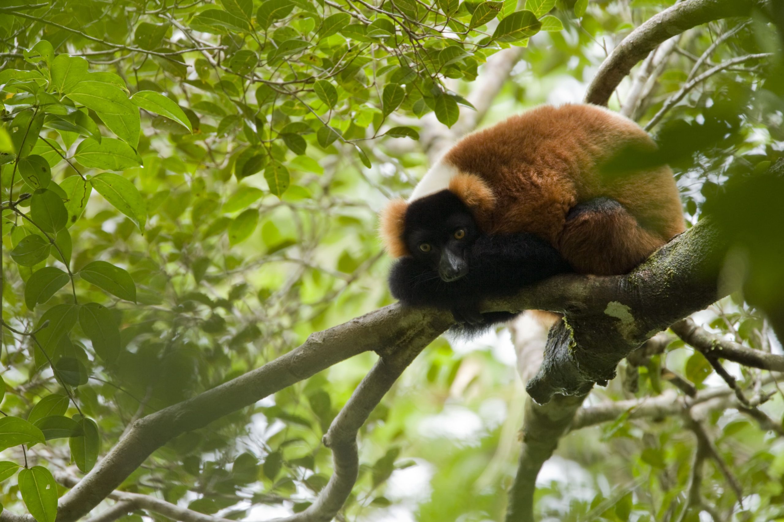
3 - Birdwatching
4 - Night tour
5 - Snorkelling in private marine parks
1 - Masoala Interpretation Center is located 1 km from downtown Maroantsetra at the environmental campus
2 - Guichet unique Masoala / MNP Masoala office is located 1 km from downtown Maroantsetra at the environmental campus
3 - MNP Masoala liaison office is located in downtown Antalaha “rue de commerce”
4 - Refectory and toilets 50 m from the entrance to Masoala NP
Download the reference document to find out more about park fees and charges.
Tours | Summary | Difficulty | Duration | Tour plans |
---|---|---|---|---|
Akôhovohitry (grande boucle Tampolo) | Faune, flore, paysage : |
4h à 5h |
||
Cascade | Faune, flore, paysage : Euryceros prevostii, Oriolia bernieri, petite cascade, … |
1h30 à 2h |
||
Varignena | Faune, flore, paysage : Varieca rubra, Eulemur albifrons, Euryceros prevostii, Uapaca sp, Calumna parsonii.. |
1h30 à 2h |
||
Vapaka | Faune, flore, paysage : |
2h à 3h |
||
Palmiers | Faune, flore, paysage : Euryceros prevostii, Eulemur albifrons, palmiers, … |
1h à 2h |
||
Tsiveravera à Andranonala | Faune, flore, paysage : tsiveravera, voay, oiseaux acquatique, akohivohitra |
2h à 2h30 |
||
Rantôtry | Faune, flore, paysage : Caluma parsonii, variroux, Elemur albifrons, serpent BOA, … |
1h à 2h |
Immerse yourself in the unique biodiversity of our national parks and discover our commitment to conservation and ecosystem protection. Marvel at unspoilt landscapes and exceptional wildlife. Together, we create a model of responsible and beneficial coexistence